


Spotlights
Geographic Information System Analyst (GIS Analyst), Geographic Information Systems Administrator (GIS Administrator), Geographic Information Systems Analyst (GIS Analyst), Geographic Information Systems Coordinator (GIS Coordinator), GIS Technician (Geographic Information Systems Technician), Resource Analyst, Remote Sensing Specialist, Geospatial Data Scientist, Geospatial Solutions Architect, Geomatics Engineer
The Earth’s surface is a fascinating area of study, but there are countless challenges to gathering and understanding data about it. That’s why computer scientists created geographic information systems (GIS) to help capture, examine, and display data from various sources. From mountain ranges to suburban streets, the information that GIS programs provide can be used for thousands of applications. But it takes trained experts — known as Geographic Information Systems Specialists — to properly use these complex computer systems.
GIS Specialists’ duties may involve designing or developing GIS systems and databases, which they then use to help scientists and researchers on various projects requiring geospatial data on certain locations. By feeding data into mapping programs, they can create and customize maps incorporating all sorts of information. The possibilities are practically endless, but a few examples are: maps showing population and democratic statistics, maps showing wildlife habitats, and maps displaying features of hard-to-reach terrain.
GIS technology is utilized by local governments for public works, planning and environmental management, and property records. It’s also relied upon in real estate, public safety, defense, transportation, health management, natural resource extraction, and several other fields. Many consider Google Maps to be a GIS that connects to GPS (global satellite positioning) to provide free navigational services!
- Helping capture and utilize geospatial data for planning purposes
- Empowering thousands of organizations with tools to improve operations
- Safeguarding human workers from the labor and hazards of manual mapping
Working Schedule
- Geographic Information Systems Specialists usually work full-time. In some cases, overtime is needed when a job is urgent. Some may only work in part-time positions, as needed.
Typical Duties
- Discuss project scope, expectations, budgets, timelines, and responsibilities
- Stay knowledgeable on a vast array of project types, including those involving civil engineering, electrical engineering, surveys, solar and wind energy, land development for residential and commercial use
- Research methods and places from which to gather data
- Gather and evaluate data from a variety of approved sources such as remote sensors
- Liaison with field support staff, as required
- Design and help build integrated computer systems, databases, modeling programs, and scientific/mathematical models
- Modify existing Geographic Information Systems databases, as needed
- Code GIS programs, perform functional tests, and troubleshoot errors
- Suggest GIS improvements, upgrades, and other changes
- Maintain technical documentation of work processes
- Prepare and input data into databases. Evaluate existing data already loaded
- Run data analysis and take note of trends and patterns
- Perform geospatial modeling and analysis
- Review aerial photos and orthoimages
- Decide upon appropriate cartographic elements to use for reports
- Use GIS to prepare reports, graphics, tables, data layers, 3D
renderings, maps, etc. - Interpret results for clients or stakeholders
- Collaborate with relevant staff or teams; discuss findings
Additional Responsibilities
- Research ways for GIS to work with Global Positioning Systems software
- Work on GIS mobile apps
- Ensure quality control and data accuracy
- Offer training and technical support to users
- Stay up to date on industry changes and technological advancements
- Attend professional organization events to share information and learn from others
Soft Skills
- Activities Coordination
- Analytical
- Attention to detail
- Collaboration
- Critical thinking
- Deductive and inductive reasoning
- Detail-oriented
- Impartial
- Independent
- Monitoring
- Normal color vision
- Objective
- Organized
- Patient
- Perceptive
- Problem-solving
- Reading comprehension
- Strong communication skills
- Time management
- Visualization
Technical Skills
- Basic engineering principles and procedures
- Computer-aided design (CAD) programs
- Data analysis software
- Database management systems
- Design software, blueprints, 3D models, technical plans
- Development environment software
- Enterprise resource planning
- Geographic information systems, such as ESRI ArcGIS
- Geospatial industry programming languages, including Python, JavaScript, C+, HTML/CSS, Swift, Java, C#, SQL, PHP, Rust, Lotlin, Ruby, TypeScript, Matlad, Go, etc.
- Google Earth, KMZ files, and lidar
- Graphics/photo imaging programs
- Map creation software like CDA International’s Manifold System or ITT Visual Information Solutions
- Mobile location-based services software
- Previous work in/familiarity with consulting engineers and/or surveyors
- Scientific software, such as Coordinate Geometry COGO
Understanding of geography
- Banks
- City, state, and federal agencies
- Civil engineering companies
- Commercial businesses and factories
- Communications systems installation providers
- Education and research institutions
- Environmental science agencies
- Fire alarm/security system installers
- Forestry services
- Healthcare and human services agencies
- HVAC installers
- Insurance companies
- Law enforcement agencies
- Political science groups
- Real estate agencies
- Retail businesses
- Supply chain management companies
- Urban planners
- Utility providers
GIS technology is, or can be, used in virtually every industry imaginable! To get a feel for just how reliant we’ve become on these critical systems, check out Nobel’s 20 Ways GIS Data is Used in Business and Everyday Life. GIS is a core asset used to make important decisions that impact everything from company profits to public safety. Because of our dependence on GIS, GIS-generated data and results must be as accurate as possible.
GIS Specialists are the key to making sure the systems perform as needed and provide trustworthy output. A dated example of GIS gone wrong was pointed out on Stack Exchange, which noted how the incorrect use of spatial aspects completely misrepresented the “potential reach of North Korea’s missiles.” One simple oversight caused The Economist to report a massive underestimation of a possible military threat’s true scope.
The field of GIS was born in the early 1960s and has developed nonstop ever since. Current trends include the increasing use of 3D analysis to add value to projects. Another area seeing exciting change is Web GIS, which brings the power of these systems to much larger communities. This, in turn, is expanding opportunities, enticing more people to learn GIS skills and add to the advancement.
In addition, the integration of GIS with Building Information Modeling and Computer-aided Drafting and Design is transforming and expanding the capabilities of these systems. Of course, as with so many other fields, Artificial Intelligence and Machine Learning have entered the fray to tap into the full potential of GIS while drawing upon real-time and “big” data.
Each of the above trends is so broad-ranging that no GIS Specialist can study them all, but it’s advisable to be familiar with all the changes and innovations happening.
Geographic Information Systems Specialists probably loved working with computers at an early age. They might have taken an interest in how things work or in data, statistics, figures, and even trivia. They may also have enjoyed using software to create art or graphic designs. Future specialists may have had a strong interest in some particular field, such as environmental studies, that they wanted to improve with the use of GIS technology.
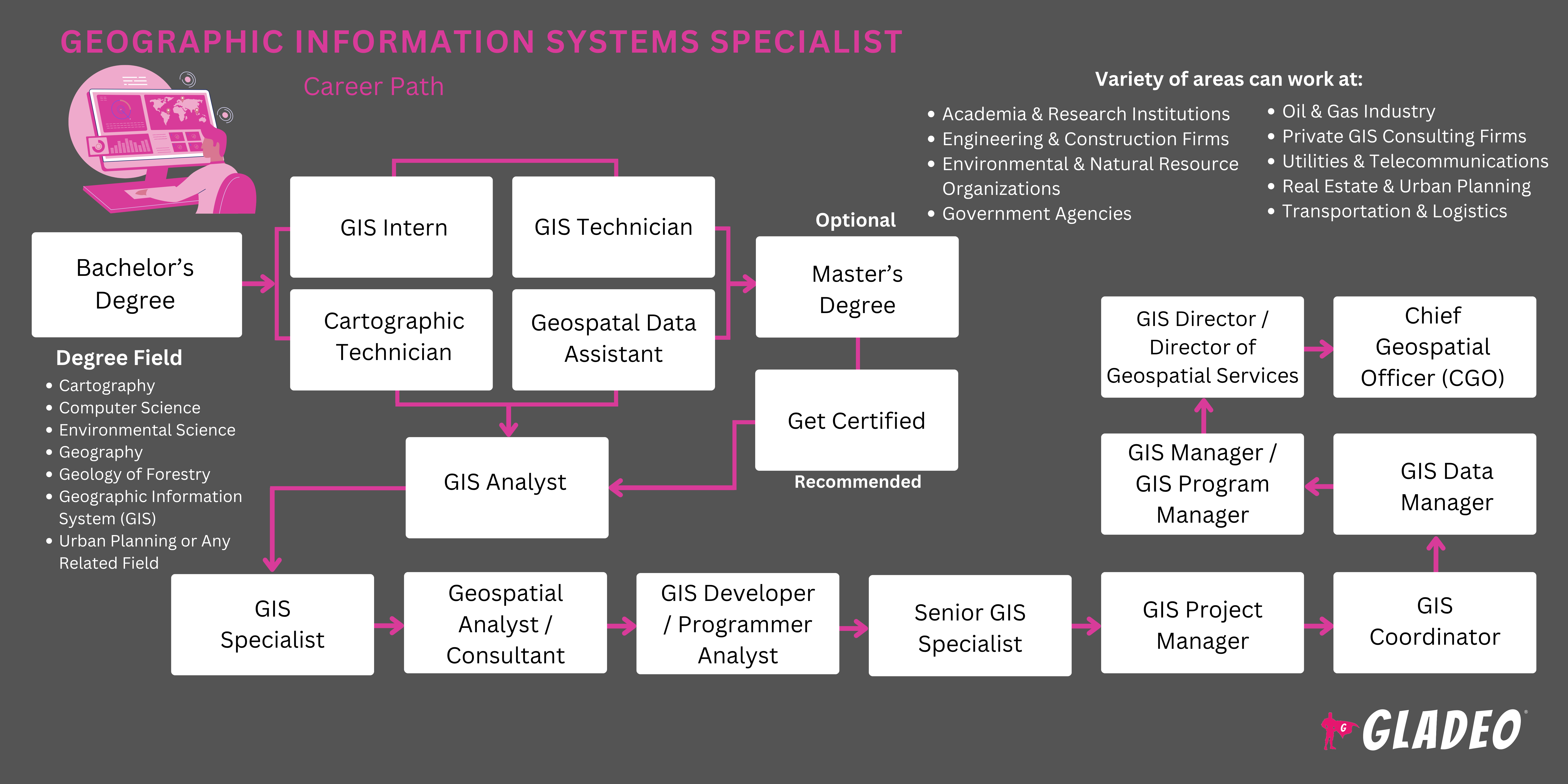
- GIS Specialists need at least a bachelor’s degree in GIS, geography, or environmental studies
- Other related majors may be considered if the student has enough relevant GIS experience
- Students will need to learn how to use various software programs such as Esri ArcGIS Desktop suite for advanced analytics, 2D and 3D, image processing, advanced visualization, connecting and sharing, and data management
- Other topics of learning include:
- AutoCAD and DWG files
- Cartographic methods, theories and principles
- Coordinate geometry COGO
- Coordinate systems
- Geodatabases
- GIS scripting languages like Python, JavaScript, C+, HTML/CSS, Swift, Java, etc.
- Google Earth and KMZ files
- GPS data collection and management
- LiDAR datasets
- Map creation software like CDA International’s Manifold System or ITT Visual Information Solutions
- Shapefiles
- Vector and raster datasets
- There are several national certifications available for GIS Specialists, including:
- Adobe Systems Incorporated - Adobe Campaign Classic Business Practitioner Expert Certification
- American Society for Photogrammetry & Remote Sensing - Imaging & Geospatial Information Society -
- Certified GIS/LIS Technologist
- Certified Mapping Scientist - UAS
- Certified Mapping Scientist Lidar
- Certified UAS Technologist
3. Environmental Systems Research Institute -
- ArcGIS API for JavaScript
- ArcGIS Desktop Associate 10.5
- ArcGIS Desktop Entry 10.5
- ArcGIS Desktop Professional 10.5
- Enterprise Administration Associate 10.5
- Enterprise Geodata Management - Associate 10.5
- Enterprise Geodata Management - Professional 10.5
- Enterprise System Design Associate 10.5
4. GIS Certification Institute - Geographic Information Systems Professional
5. National Geospatial-Intelligence Agency -
- Professional Certification Applied Science
- Professional Certification Fundamentals
- Professional Certification GEOINT Collection
- Professional Certification Geospatial Analysis
- Professional Certification in Geospatial Data Management
- Professional Certification in Human Geography
- Professional Certification Imagery Analysis
- Professional Certification Maritime
6. United States Geospatial Intelligence Foundation -
- Certified GEOINT Professional- GIS & Analysis Tools
- Certified GEOINT Professional- Remote Sensing & Imagery Analysis
- Certified GEOINT Professional- Geospatial Data Management
7. WorldatWork - Certified Benefits Professional
- Consider the cost of tuition, discounts, and local scholarship opportunities (in addition to federal aid)
- Think about your schedule and flexibility when deciding whether to enroll in an on-campus, online, or hybrid program
- Check out the program’s faculty awards and accomplishments to see what they’ve worked on
- Look closely at the facilities they teach in and the equipment and software they let students train on
- Review job placement stats and details about the program’s alumni network
- High school courses such as computer science, computer programming, geography, and economics can help prepare students for a GIS college program
- Consider applying for a GIS-related apprenticeship
- If you’re able, try to gain some work experience through part-time jobs that give you skills and practice
- Write down the names and contact info of people you work with, as they might serve as future job references one day!
- Study books, articles, and video tutorials related to the many applications of GIS tech. Try to pin down which area you want to work in after graduation
- Ask a few seasoned GIS Specialists if you can shadow them to get a feel for their day-to-day activities
- Join professional organizations like the National Geospatial-Intelligence Agency to learn about trends and grow your network
- Get certified in a specialized area to bolster your credentials
- Volunteer for school activities where you can learn how to work effectively as a team, practice your soft skills, and manage projects
- Don’t wait to start drafting your resume. Keep a log of the software and equipment you’ve learned to use, so you don’t lose track
- Review criteria for jobs in advance by checking out postings on Indeed and other job portals
- GIS-related apprenticeships may be a good way to break into this line of work
- Rack as up as much experience as you can before applying
- Set up alerts on job portals such as Indeed, Simply Hired, Glassdoor, and Zippia
- Read ads carefully to make sure you meet all the requirements to apply
- Reach out to working GIS Specialists to ask how they got their jobs
- Let your network know you’ve begun your job search so they can alert you about openings
- Ask your college’s program or career center for assistance with job-seeking
- Many programs serve as pipelines to recruiters so let them know you’re ready for work!
- Review GIS Specialist resume templates to get ideas for wording and formats
- List all education, skills, training, and work history on your resume, and ask a friend or editor to review
- Ask former teachers and supervisors if they’ll serve as personal references
- Study GIS Specialist interview questions to prep for interviews!
- Hop on Quora and start asking job advice questions
- Always dress appropriately for job interview success!
- Stay on top of the game by constantly improving your skills and learning new things through online courses such as Bootcamp GIS’ Agile Management of a Modern GIS
- Complete a master’s or advanced certifications to qualify you for higher levels of authority
- Talk to peers about new developments and uses for GIS
- Demonstrate thought leadership and help your employer use their GIS to the maximum benefit
- Learn how to effectively communicate what benefits you’re bringing to the table
- Build trust by being accountable, meeting deadlines, and ensuring accurate, high-quality results
- Do diligent research to gather data from reliable sources
- Treat everyone with respect and build your reputation as a professional with integrity
- Be transparent about capabilities and offer feasible solutions
- Watch and learn from more senior GIS Specialists. Ask questions and take notes of best practices
- Grow your professional network in the community and via increased engagement with professional organizations
- Try to win awards and recognitions that’ll look good on your resume
- Have frank discussions with your supervisor. If your employer doesn’t have opportunities for advancement, consider whether you want to stay or move on
Websites
- Adobe Systems Incorporated
- American Association of Geographers
- American Society for Photogrammetry & Remote Sensing - Imaging & Geospatial Information Society
- American Society for Photogrammetry and Remote Sensing
- Environmental Systems Research Institute
- Geospatial Information and Technology Association
- GIS Certification Institute
- National Geospatial-Intelligence Agency
- National States Geographic Information Council
- United States Geospatial Intelligence Foundation
- URISA
- WorldatWork
Books
- A Primer of GIS, Second Edition: Fundamental Geographic and Cartographic Concepts, by Francis Harvey
- GIS For Dummies, by Michael N. DeMers
- Imagery and GIS: Best Practices for Extracting Information from Imagery, by Kass Green, Russell Congalton, et al
- Learning Geospatial Analysis with Python: Understand GIS fundamentals and perform remote sensing data analysis using Python 3.7, by Joel Lawhead
O*Net lists the following related occupations to think about!
- Cartographers and Photogrammetrists
- Data Scientists
- Geodetic Surveyors
- Software Developers
- Surveying and Mapping Technicians
Newsfeed

Featured Jobs
Online Courses and Tools