


Spotlights
Geomatics Engineer, Geospatial Analyst, Land Surveyor, Geographic Information Systems (GIS) Specialist, Topographic Surveyor, Cadastral Surveyor, Remote Sensing Specialist, Mapping Technician, Cartographic Designer, Geospatial Data Analyst
The roles of Surveyors and Cartographers are not exactly the same, but they work together so closely that we decided to bundle the two fields into one profile! As Environmental Science notes, both “gather data and map the landscapes all around us,” and their work is “used for construction, mapping, and geological study.”
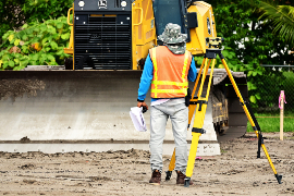
Surveyors physically visit the actual sites they need to map. They use measuring tools and techniques to gather data which is later plugged into the software. Cartographers use captured information in the creation of maps made for various purposes, such as showing borders or geographic features like elevation and water sources. The ongoing efforts of both Surveyors and Cartographers are needed to ensure maps are kept accurate and up-to-date. While Surveyors are exposed to weather conditions and potential outdoor hazards, Cartographers spend more time indoors working with programs but may have to travel as needed
- Helping capture and utilize geospatial data for mapping and planning purposes
- Empowering thousands of organizations with tools to improve operations
- Potentially saving lives by mapping and finding natural disaster spots
Working Schedule
- Surveyors and Cartographers usually work full-time. In some cases, overtime may be necessary if a task is urgent. Some may only work in part-time positions, as needed.
Typical Duties
Surveyors
- Research and review existing maps, surveys, deeds, land titles, lease contracts, and other pertinent documentation related to legal geographic boundaries
- Visit various locations where fieldwork is to be done
- Take note of important landmarks and other fixed reference points and features
- Use equipment to calculate accurate distance and angle measurements of various surfaces
- Direct other survey team members, as needed
- Create sketches and draft maps of locations, showing relevant topographical features and property lines
- Ascertain terrain heights, depths, shapes, dimensions, and other aspects necessary to determine property lines
- Record latitudes and longitudes of boundaries using GPS and other tools such as theodolites, transits, and levels
- Record survey data and use it to prepare reports, charts, maps, and other documents
- Produce written survey findings with visuals for clients, agencies, or in some cases legal professionals
- Work with engineers and architects, as needed
- Calibrate and modify survey instrumentation
- Take geodetic measurements to help assess geomorphic and topographic aspects
- Provide sworn testimony in property dispute cases
- Plan out aerial survey projects including which equipment to use
- Conduct surveys of bodies of water such as lakes and rivers
- Stay up to date on developments surveying/mapping technologies
- Use photogrammetric map and electronic data processing tools
Cartographers
- Determine valid sources for collecting geographic data; establish criteria standards for data usage
- Gather geographic data from surveys, reports, aerial photos, satellite images, remote sensors, and existing maps or charts
- Filter data to ensure only the most current, relevant, and accurate information is used
- Examine legal documents listing or showing current property boundaries
- Create comprehensive databases
- Decide upon suitable map content, layout, sizes, colors, and other factors, based on employer’s needs
- Use suitable data and programs to make visual representations such as digital and graphic maps, charts, 3D models, tables, etc.
- Reference important geographic features and details, including control points, hydrography, geodetic points, elevations, planimetric features, and topographic features
- Review final outputs for accuracy
- Use precision stereoplotting tools and drafting instruments to note details on photos
- Conduct site visits as needed to observe and verify accuracy of information
Additional Responsibilities
- Update maps regularly using current data
- Train and supervise other team members, as needed
- Stay up to date on industry changes and technological advancements
- Attend professional organization events to share information and learn from others
Soft Skills
- Activities coordination
- Analytical
- Attention to detail
- Collaboration
- Critical thinking
- Deductive and inductive reasoning
- Detail-oriented
- Impartial
- Independent
- Monitoring
- Normal color vision
- Objective
- Organized
- Patient
- Perceptive
- Problem solving
- Reading comprehension
- Strong communication skills
- Time management
- Visualization
Technical Skills
- Computer aided design (CAD) programs
- Data analysis software
- Database management systems
- Design software, blueprints, 3D models, technical plans
- Development environment software
- Enterprise resource planning
- Geographic information system, such as ESRI ArcGIS
- Geospatial industry programming languages, including Python, JavaScript, C+, HTML/CSS, Swift, Java, C#, SQL, PHP, Rust, Lotlin, Ruby, TypeScript, Matlad, Go, etc.
- Google Earth, KMZ files, and lidar
- Graphics/photo imaging programs
- Map creation software like CDA International’s Manifold System or ITT Visual Information Solutions
- Mobile location-based services software
- Previous work in/familiarity with consulting engineers and/or surveyors
- Scientific software, such as Coordinate geometry COGO
- Understanding of geography
- Architectural and engineering services
- Construction
- Governmental agencies
- Management, scientific, and technical consulting services
- Mining, quarrying, and oil and gas extraction
The work of Surveyors and Cartographers is vital for many industries and accurate results are often critical. Precision is the name of the game and mistakes can be costly. Major land disputes can be resolved with accurate surveys, while inaccurate results can lead to expensive legal battles.
In addition, many companies make business decisions based on maps and other information supplied by Surveyors and Cartographers. Expectations run high and related sacrifices include reputational damage for the workers or even financial liability in some cases. This is why Surveyors may need business insurance. Another sacrifice is the need for frequent travel and outdoor work, sometimes during inclement weather conditions.
Surveyors and Cartographers must keep up with the significant changes that are revolutionizing their lines of work. Remote-control unmanned aerial vehicles (UAVs) and drones aren’t new to the world of surveying, but they are increasingly relied upon for their flexibility, ease of use, and ability to obtain data that would otherwise be much harder (if not impossible) to acquire!
But another disruptive technology — the cloud — has expanded capabilities in terms of gathering and managing large datasets, especially with the advent of the 5G mobile network. Speaking of mobile, mobile mapping systems are being used to scan all sorts of environments very quickly, cutting down survey times and leading to notable cost savings over the long term.
Surveyors and Cartographers might have appreciated being outdoors and paying attention to the details of their surroundings. They may have enjoyed consulting maps for navigation or to learn information about various regions of the world. Surveyors were possibly more “hands-on” types who liked rolling up their sleeves to work with gadgets. Cartographers may have spent more time working with computers and data. Both were likely a bit obsessed with accuracy in whatever they were up to!
Surveyors
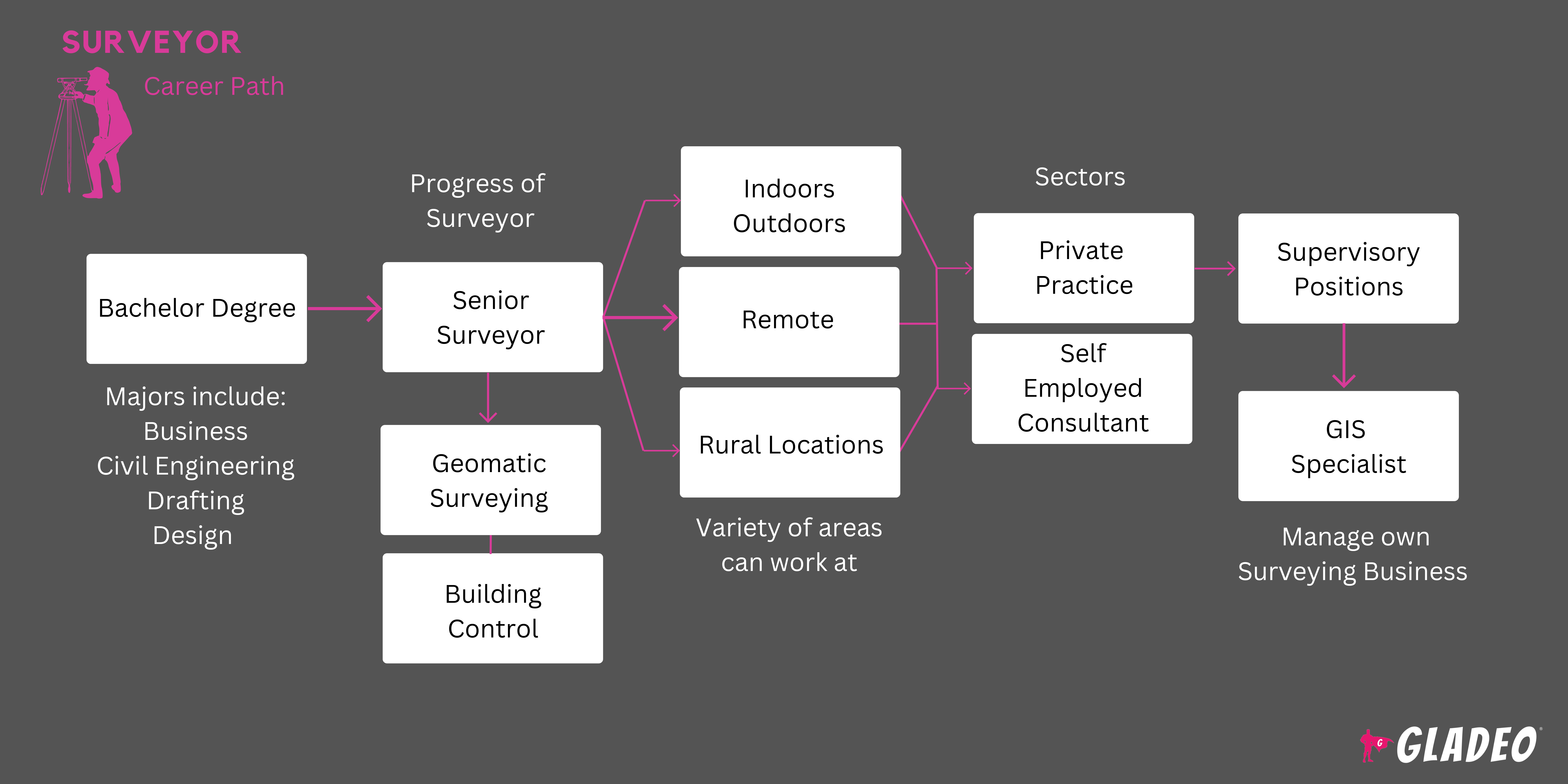
- Surveyors and Cartographers usually need at least a bachelor’s degree, ideally from an ABET-accredited program
- Surveyors major in quantity or land surveying, hydrographic surveying, engineering (usually civil or mechanical), or in some cases natural resources
- They must later obtain state licensure after ~4 years of working and passing the National Council of Examiners for Engineering and Surveying’s Fundamentals of Surveying and Principles and Practice of Surveying exams
- Surveyors must learn how to use equipment such as theodolites, measuring tape, total stations, 3D scanners, GPS/GNSS, levels, and rods, among many others
- They will also learn common surveying software like Civil 3D, AutoCAD, BIM 360, Revit, Navisworks, and more
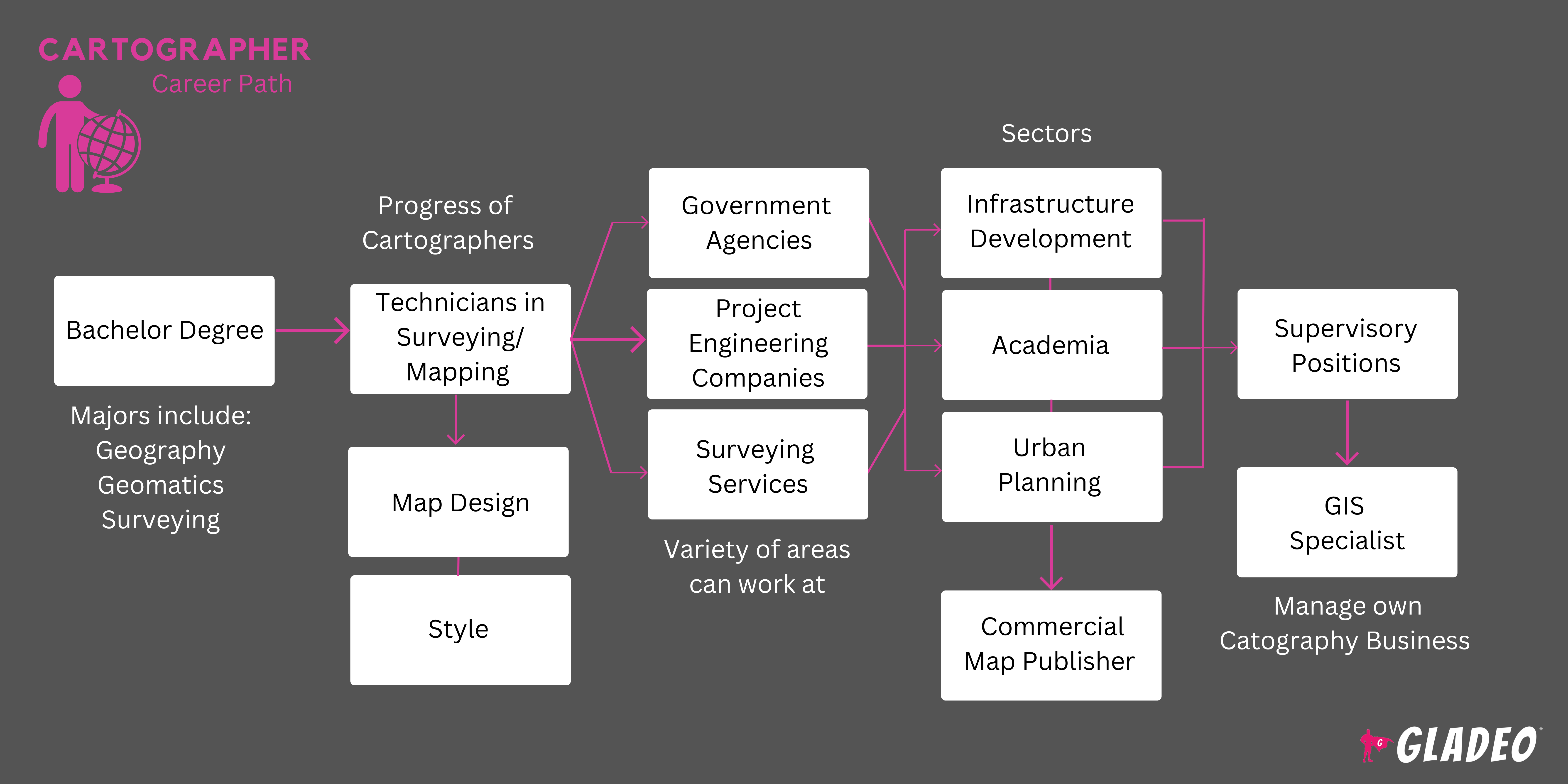
Cartographers
- Cartographers major in cartography, surveying, geography, or geomatics, with plenty of coursework in programming, mobile mapping, geographic information systems (GIS), and related topics
- Some states require Cartographers to obtain a Surveyor license
- Students will need to learn how to use various software programs such as ArcGIS and MapInfo Pro
- Other topics of learning include Boeing SoftPlotter, AutoCAD, lidar sensors, and cartographic methods, theories and principles,
- There are several national certifications available for Surveyors, including:
- American Association of Professional Landmen -
- Registered Professional Landman
- Registered Landman
- Certified Professional Landman
- American Society for Photogrammetry and RemoteSensing -
- Certified Photogrammetric Technologist
- Certified GIS/LIS Technologist
- Coordinate Metrology Society - Certified Portable 3D Metrologist Level 1
- GIS Certification Institute - Geographic Information Systems Professional
- Green Business Certification Inc. - LEED AP Neighborhood Development
- National Society of Professional Surveyors -
- Certified Surveyor Technician
- Certified Federal Surveyor
- American Association of Professional Landmen -
- Certs for Cartographers include:
- American Society for Photogrammetry and Remote Sensing -
- Certified Mapping Scientist, Remote Sensing (ASPRS)
- Certified Mapping Scientist, GIS/LIS (ASPRS)
- International Association of Assessing Officers - Cadastral Mapping Specialist
- National Geospatial-Intelligence Agency -
- GEOINT Professional Certification Cartography
- GEOINT Professional Certification Imagery Science
- American Society for Photogrammetry and Remote Sensing -
- Note, the United States Geospatial Intelligence Foundation “temporarily and voluntarily suspended the Certified GEOINT Professional (CGP) program for a period of three (3) years, starting February 1, 2021.” Please check their website for more information and other opportunities
- Consider the cost of tuition, discounts, and local scholarship opportunities (in addition to federal aid)
- Think about your schedule and flexibility when deciding whether to enroll in an on-campus, online, or hybrid program
- Check out the program’s faculty awards and accomplishments to see what they’ve worked on
- Look closely at the facilities they teach in and the equipment and software they let students train on
- Review job placement stats and details about the program’s alumni network
- Volunteer for school activities where you can learn how to work effectively as a team, practice your soft skills, and manage projects
- Sign up for high school courses such as arithmetic, algebra, geometry, trigonometry, computer science, computer programming, geography, mechanical drawing, and drafting
- Consider applying for a land survey or cartography apprenticeship
- Future Surveyors might want to gain work experience through part-time construction jobs. The practice may help develop a few skills with surveying equipment, plus build up physical stamina
- Write down the names and contact info of people you work with, as they might serve as future job references one day!
- Study books, articles, and video tutorials related to Surveying or Cartography depending on your goals
- Ask a few seasoned Surveyors or Cartographers if you can shadow them to get a feel for their day-to-day activities
- Join professional organizations to learn about trends and grow your network
- If you meet the eligibility requirements, get certified in a specialized area to bolster your credentials
- Think about which state you want to work in, so you can review their licensure requirements
- Consider which industry you want to focus on, and compile a list of potential employers. Review their websites to learn more about their needs and check out their career pages
- Don’t wait to start drafting your resume. Keep a log of the software and equipment you’ve learned to use, so you don’t lose track
- Review criteria for jobs in advance by checking out postings on Indeed and other job portals
- Survey or Cartography-related apprenticeships may be a good way to break in
- Learning how to use as many relevant tools, pieces of equipment, or programs as you can before applying
- Upload your resume on job portals such as Indeed, Simply Hired, Glassdoor, and Zippia and keep it current
- Note, some national and state professional associations that list jobs, too, such as the National Society of Professional Surveyors’s job board, GIS Jobs Map, or the Professional Land Surveyors of Oregon job board
- Search for job ads and screen them carefully to make sure you meet the requirements to apply
- Reach out to working Surveyors or Cartographers to ask for job-seeking tips
- Spread the word through your network that you’ve begun your job search
- Move to where the most job opportunities are! The states with the highest employment levels for Surveyors are Texas, California, Florida, Colorado, and Georgia. For Cartographers, it’s Texas, Colorado, California, North Carolina, and Virginia
- Ask your college’s program or career center for help with resume writing, mock interviewing, job fair schedules, etc.
- Many programs serve as pipelines to recruiters so let them know you’re ready for work!
- Review Surveyor and Cartographer resume templates to get ideas for wording and formats
- List all education, skills, training, and work history on your resume
- Consider having your resume drafted or at least reviewed by a professional resume writer or editor
- Ask former teachers and supervisors ahead of time if they’ll serve as personal references. Don’t catch them off guard by listing their contact info without permission
- Study Surveyor and Cartographer interview questions to see what you might be asked
- Make an account on Quora to ask job advice questions from workers in the field
- Always dress appropriately for job interview success!
- During your internship work experience phase, pay close attention and learn all you can. Even though you’re out of school, you’re still in “learning mode” during those first years (and beyond, too)
- Keep progressing! Get licensed as soon as you’re eligible to apply and take the Fundamentals of Surveying and the Principles and Practice of Surveying exams
- Stay on top of the game by constantly improving your skills and learning new things through online courses, a master’s degree, or advanced certifications to qualify you for higher levels of authority
- Build trust by being accurate and accountable. Meet deadlines and ensure high-quality results
- Watch and learn from more senior Surveyors and Cartographers. Ask questions and take notes of best practices
- Grow your professional network in the community and via increased engagement with professional organizations
- Give lectures at organizational events, publish articles, and try to win state and national awards to enhance your professional reputation
- The NSPS Surveying Excellence Award is just one example of possible recognition to strive for!
- Schedule a conversation with your supervisor or manager to discuss opportunities for advancement
- If needed, consider applying to new jobs with more promotion potential — or launch your own land surveying company!
Websites
- American Society for Photogrammetry and Remote Sensing
- Association of American Geographers
- Cartography and Geographic Information Society
- GIS Certification Institute
- National Society of Professional Surveyors
- United States Geospatial Intelligence Foundation
Books
- Cartography, by Kenneth Field
- GPS for Land Surveyors, by Jan Van Sickle
- Land Surveying Simplified, by Paul L. Gay
The technology behind surveying and cartography is always evolving, and sometimes it’s hard to keep up. Both jobs are challenging and rewarding, but may not be the best fit for some workers. For those who want to consider a few alternative paths, the Bureau of Labor Statistics lists related occupations to think about!
- Architects
- Civil Engineers
- Construction and Building Inspectors
- Drafters
- Environmental Scientists and Specialists
- Forest and Conservation Workers
- Geographers
- Geological and Hydrologic Technicians
- Landscape Architects
- Surveying and Mapping Technicians
- Urban and Regional Planners
Newsfeed

Featured Jobs
Online Courses and Tools